This page is under construction. Please check back soon for updates - See more at: http://www.epd.org/storm-water-management#sthash.4JSv5MHk.dpuf
This page is under construction. Please check back soon for updates - See more at: http://www.epd.org/storm-water-management#sthash.4JSv5MHk.dpu
February 16, 2016 Stormwater Subcomittee Update
The three remaining sites were discussed (East End, Wild Meadows Trace and Crestview) and as a response to the City’s January 13 request that the Park District forgo replacement of and compensation for these sites and instead work with the City to ask IDNR to make an exception to their policy against off-site stormwater to OSLAD funded sites, the District subcommittee shared the following statement: "At this point in time, the Park Board is not interested in encumbering additional open space with detention basins to provide relief for the approximately 11 remaining homes that would be impacted. However, as we discussed at our last meeting on January 14, the District believes that Park and City staff should discuss alternative ideas for the three sites, similar to those the City has already utilized, including the purchase of properties, storage vaults underneath parking lots and underground storage that could provide stormwater detention as well as open space and recreational opportunities at grade level." City was not receptive to the idea of considering alternative approaches to providing stormwater detention in these locations. The next subcommittee meeting will be held March 24, 2016 at 7 p.m. at City Hall.
August 27, 2015
A new concept draft/map was provided by the City to the Park District stormwater subcommittee on August 27, 2015. This map is attached below.
Burke Report and Rationale Overview
After the severe flooding experienced in June 2010, the City of Elmhurst hired Burke Engineering to conduct a study, the main objective of which was to analyze 10 key flood problem areas in the City and to develop concept-level drainage improvements to alleviate the flooding in each area. Of the 10 flood areas identified, Burke recommended that Park District property could be utilized to partially alleviate flooding in five of those areas.
Burke utilized available data and calibrated computer modeling to simulate flood reduction benefits. Proposed drainage improvements analyzed in this study included: increased storm sewer sizes, constructing relief sewers, creating flood storage in open space, providing flood storage underground, and increasing pumping rates of existing stormwater pumping stations. No other possible improvements were considered.
Burke provided conceptual-cost estimates, but these estimates did not include land acquisition, temporary/permanent construction easements, relocation of utilities, or the cost of recreation facilities in open space.
Burke provided more than one alternative for most study areas with the goal of providing 50-year flood protection or relief for the 100-year flood event. (The terms "50-year flood" and 100-year flood" are used to define a rainfall event that has a 1% probability of occurring every 50 years, or once every 100 years respectively.)
Burke proposed a number of improvements for each alternative. Listed below are proposed improvements directly impacting Park District property.
Burke Recommendations for East End Park
Impacts Flood Study Area - Geneva Avenue
Geneva Avenue area defined by Burke as area located west of Tri-State Tollway, between North Avenue and First Street. The flood problem area consists of a low-lying area along Geneva Avenue, between Third Street and North Avenue.
Storm sewers and overland flow routes convey stormwater runoff through this low-lying area toward East End Park. Houses along the east side of Geneva Avenue block the overland flow route and cause stormwater runoff to pond in this location. A single 33-inch diameter storm sewer serves as the only outlet for this area. East End Park, which drains through two pipes under the southbound entrance ramp of the Tri-State Tollway, fills up with stormwater when the capacities of these pipes are exceeded, and the ponding of stormwater in the park eventually reaches the houses along the east side of Geneva Avenue. Several proposed improvements were evaluated to increase the level of flood protection for the study area. Due to the lack of sites available for flood storage in this study area, the proposed alternatives focused on utilizing East End Park. Due to the existing topography, East End Park currently functions as a stormwater detention area, as evidenced by the July 2010 inundation area. The goal of the proposed drainage improvements is to eliminate the Geneva Avenue street/structural flooding by implementing conveyance improvements and creating offsetting flood storage at East End Park .
Alternative #1 - 100-year Flood Relief - Storage
- Installation of 950 linear feet of 2-foot by 5-foot box relief sewer between the low spot at Geneva Avenue and the East End Park flood storage basin.
- Reroute existing 36-inch diameter storm sewer around proposed flood storage area and tie-in to existing 12-inch from Caroline Avenue.
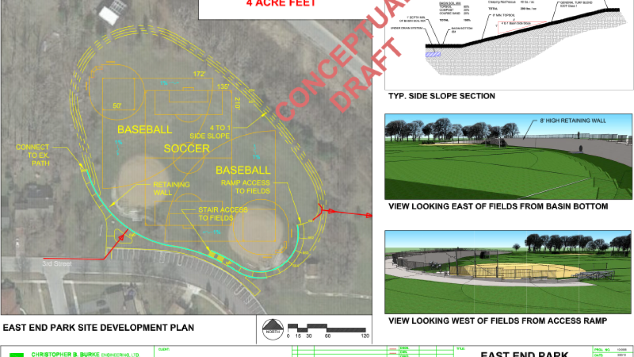
- Provide an additional 4-acre feet of flood storage in East End Park. The existing outlet of the flood storage area will remain unchanged.
Impacts Flood Study Area - Pine Street
Number of Homes Protected from a 100-year Event by utilizing East End Park as Detention Basin = 15 Homes